
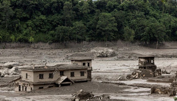
KATHMANDU/BEIJING: A huge wall of mud and rock collapsed into a river on the Himalayan border of Nepal and China's Tibet on Wednesday, triggering catastrophic flooding on the Nepali side that killed at least 95 people and left hundreds of tourists missing. In a still-unfolding disaster, verified videos showed dozens of people swept away at the border, with authorities on both sides fearing far higher casualties and massive destruction. Houses, roads and power projects were swept away in Nepal, while officials in Tibet said they feared "major casualties", with some people missing in the county of Gyirong after a mudslide hit a border land crossing.
Initial reports suggested an earthquake in the area could have triggered an avalanche and caused the floods, Nepal's foreign minister, Shisir Khanal, told the country's parliament on Wednesday, local media reported. Security footage captured on the Chinese side of the Nepal-Tibet border showed many people fleeing before a torrent of rock, mud and water destroyed buildings, vehicles and took many lives. With the deluge of muddy water sweeping down from an estimated nearly 2,000 metres (6,560 feet) above sea level, flood alerts were issued in the populous northern Indian states of Uttar Pradesh and Bihar, which border Nepal and where several rivers flow down the mountains into the plains.
Authorities in Bihar said they had evacuated about 5,000 people from six districts and planned to evacuate a total of 10,000 to 12,000 people. At least 341 foreign travellers were missing from the region, including more than 100 Indians, three US citizens and 12 British nationals, Nepal's tourism ministry said. Dozens of local people were also missing. Rescue teams in Nepal had recovered 95 bodies so far, police said. Local media reported 65 people were being treated in hospitals in the area and in the capital Kathmandu. South Korea separately said that eight of its nationals working on a hydropower plant were missing.
The exact cause of the mudslide could not be immediately determined, but the German Research Centre for Geosciences (GFZ) said there was a 4.4 magnitude quake approximately seven minutes before the time shown on the security footage time-stamp. An initial study of Planet Labs satellite imagery indicated that a landslide of snow and rock triggered a debris-laden flood in the Lhende river, about 20 km (12 miles) northeast of the Nepal-China Rasuwagadhi border crossing, Nepal's National Disaster Risk Reduction and Management Authority said on X. Before and after images from Planet Labs appeared to show a wide swathe of destruction on either side of the usual river course. Qianggong Zhang, head of climate and environmental risks at the Kathmandu-based International Centre for Integrated Mountain Development, said the cause of the ice-rock avalanche into the Lhende Khola river on the Nepali side was yet to be confirmed. Rescue helicopters could not land in Nepal's affected areas, officials said, with the river flowing above its normal course and television images showing widespread devastation.