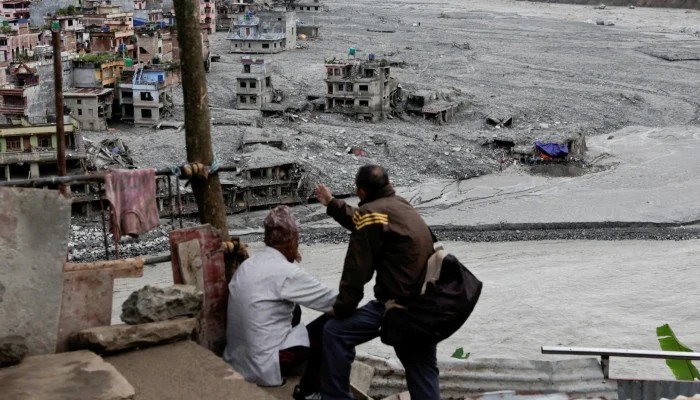
On the morning of August 26, the sky above Rasuwa in northern Nepal was clear. There was no rain and no warning. High above the Nepal-China border, a mass of ice and rock broke away and fell into the Lhende Khola, blocking the river for a few minutes before the blockage gave way. The surge that followed carried enough force to register on seismometers worldwide as a magnitude 5.2 event. The US Geological Survey later confirmed that the tremor felt in the valley was not an earthquake. It was the collapse itself. What came next took minutes, not hours. Scientists estimate the wave covered the first 22 kilometres at an average speed of around 193 kilometres per hour. The Trishuli rose by as much as nine metres in 30 minutes. Not nine centimetres. Nine metres, in the time it takes to drink a cup of tea.
At the time of writing, Nepal's National Disaster Risk Reduction and Management Authority had confirmed 1,114 deaths, with roughly 4,500 people still missing on both sides of the border and close to 12,000 rescued. Both numbers will almost certainly have moved by the time this is read. It is already the deadliest disaster Nepal has suffered since the earthquake of 2015. Thirty-two bridges and around 40 kilometres of road have gone, along with hydropower plants and the Rasuwagadhi border crossing that links Kathmandu to Tibet. Nepal was not without instruments. A monitoring station near the border was transmitting river data every ten minutes, and it did so normally until 8:40am. The 8:50am reading never arrived, because by then the station no longer existed. Word reached the Department of Hydrology and Meteorology roughly 16 minutes after the water had already crossed into Nepal, and the text alerts that followed went out to communities the flood had already passed through. The system worked as designed. It was simply designed for a monsoon river rising slowly, not for a mountain falling into it on a dry morning.
That is not a Nepali failure. It is a South Asian one, and Pakistan should read it as a letter addressed to us. Consider where the water went. The Trishuli joins the Narayani, which crosses into India as the Gandak. Within a day, India was evacuating people from low-lying areas of Bihar, Uttar Pradesh and Uttarakhand, and Bihar had opened all 36 gates of the Gandak barrage at Valmikinagar. Bodies were later recovered some 240 kilometres downstream inside India. A glacier failed on the Tibetan frontier and farmers in Bihar left their homes. What happened in Nepal did not stay in Nepal, and it never will. The Hindu Kush Himalaya is the water tower for close to two billion people, and its glaciers lost ice around 65 per cent faster between 2011 and 2020 than in the decade before.
As the ice retreats, slopes destabilise, the permafrost that cements the mountainsides thaws and meltwater collects in places nobody has mapped. The hazard is transboundary. The response remains stubbornly national. Pakistan holds more glaciers than any country outside the polar regions, and more than 3,000 glacial lakes sit across Gilgit-Baltistan and Khyber Pakhtunkhwa. The UNDP classifies 33 of them as hazardous, with around seven million people living below them. In recent years, glacial lake outburst floods have threatened dozens of communities across Gilgit-Baltistan and cut off vulnerable valleys, serving as a stark reminder of the mounting crisis.